![]()
Section 2
Deciding Where to DrillWhen drilling equipment is available, it is very tempting to get right to work drilling wells. However, wells should be carefully sited (Appendix D) so that drilling only occurs where there is a high probability of successfully penetrating into water-bearing formations and the wells can be effectively used, maintained (Section 17), and protected from contamination. While every borehole will not result in a good well, advanced planning with the community (Appendix R) will maximize the number of successful wells and minimize drilling costs.
In order to successfully site water wells, those involved must know something about the places where underground water occurs and how it got there (see Appendix C).
| To identify areas where there is a high probability of successfully drilling wells, one must first prepare a site map (Section 2.8). Consideration must be given to each of the following seven factors which are critical in siting new water wells: |
Aerial photographs, geologic reports, well logs and topographic maps are useful in studying these factors (see Section 2.9). Where available, specialists should be enlisted to use geophysical techniques to define subsurface conditions(1). This is most important in areas where air photo coverage and hydrogeological information are inadequate, where local rainfall is less than 700 mm/yr (White, 1987) and where adequate water supplies are only available in rock (Dijon, 1981). Usually, however, the best source of well siting information is talking to people who have dug local water wells and personal inspection of water wells in the area. Although this can be time consuming, it is very important and contributes to an understanding of local subsurface conditions and selection of the best place for successful water wells.
2.1 - Groundwater Depth, Quantity & Quality
Where dug wells exist, it is possible to determine the depth to water, geology and expected water quantity and quality. The history of old wells will indicate how far down the water table drops during dry seasons and will indicate how deep new wells must be. In general, the LS-100 mud rotary drill rig should only be used in areas where people are getting their water from hand dug water wells (less than 40 meters deep). Only after numerous water wells are drilled this way should drilling be attempted in areas where little information is available or where subsurface conditions (impermeable clay, hard rock, etc.) have prevented the construction of hand dug water wells.
If existing dug wells will be disinfected (Section 15) and continue to be used, the new well should be drilled as far away as possible to ensure that both wells will produce sufficient amounts of drinking water without interfering with one another (drawing water from the same part of the aquifer).
The amount of water supplied by an aquifer (water bearing formation) is as important as its quality. The only way to know exactly how much water is available is by pumping wells (Section 10.3). However, a rough estimate of yield can be made by identifying the soil and rock which comprise the aquifer.
Most sand and gravel deposits contain significant amounts of drinking water. However, the amount of water which can actually be pumped depends on how thick these deposits are and their permeability (how easy it is for water to flow through it). In general, the larger the grain size and the thicker the deposit, the higher the yield of the aquifer.
Unfortunately, the LS-100 cannot effectively drill past boulders (loose rocks greater than 10 cm in diameter) or through loose gravel greater than 1-2 cm diameter (it is very difficult to keep the borehole from collapsing and it is hard to carry the gravel up and out of the borehole). It is, therefore, important to inspect existing wells and valley sides, cliff faces, quarries, etc. to determine if there are boulders or coarse gravel present.
Try to avoid siting and developing wells in shallow sand and gravel deposits if the water table is less than 3 meters below surface. Under these conditions, waste water can easily infiltrate back down to the water table near the well and contaminate the drinking water supply.
Wells constructed in silt or clay soils will have very low yields regardless of how they are constructed. To compensate for this, large diameter water wells should be carefully dug so that large volumes of water can slowly accumulate in the well casing over time and provide sufficient quantities when required.
Finally, limestone, sandstone or quartzitic rock may also yield adequate quantities of water. Best yields are found where there is a thick zone of weathered rock with many cracks (fractures) (Dijon, 1981). In general, fine grained rocks, such as shale, do not serve as productive aquifers. Also, the LS-100 cannot effectively drill through cemented stone layers or hard rock like granite or gneiss. Therefore, if there are hard rock layers greater than 1 to 2 meters thick in the vicinity of the proposed drilling location, a different drill rig is needed.
During the dry season, survey for indications of groundwater by looking at the alignment of ant mounds and green vegetation in the midst of an arid landscape. Annual plants, such as grasses and ferns, are not good indicators because they come and go with the seasons. However, year-round reeds and broad leaf trees and shrubs like cedar and willow tend to grow where water is close to the surface. Some water indicator trees in West Africa are Daniella (Daniella olivieri), Kapok (Ceiba pentandra) and Baobao (Adansonia digitata).
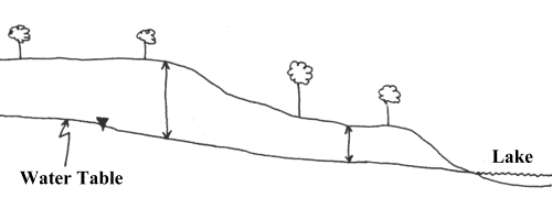
The water table commonly follows the land surface (see Figure 1). While the lowest areas (valley bottoms or depressions where water accumulates after rains) are generally the best places to drill (Dijon, 1981), ensure that the site has good access, is not subject to flooding and is not close to where contaminated surface water ponds. The presence of water bearing fracture zones may be detected by surface features such as shallow linear depressions and abrupt changes in valley alignment. Often these features are difficult to see in the field but become apparent when viewed from the air.
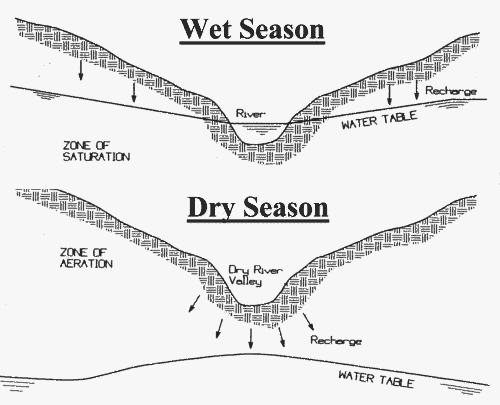
Successful wells are often drilled near rivers; groundwater may be available even if the river is temporarily dry (Figure 2). Reliable wells have even been located near broad sandy riverbeds which are active once every 5-10 years (Dijon, 1981). Water taken from wells located at least 15 m from a river is usually cleaner and cooler than water taken from the river. If the well water remains turbid after construction, the soils may be providing inadequate filtration and contaminated river water may be entering the well.
Look for springs since they indicate the presence of a water bearing formation (aquifer). A well can often be successfully drilled just uphill of the spring. Animal trails often lead to seeps and springs.
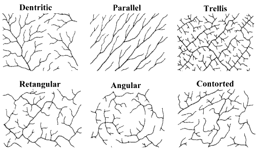
Finally, surface drainage patterns can be used to determine rock type (Figure 3):
- Trellis and rectangular drainage develops where dipping, fractured sedimentary rocks are present; these are the most favourable areas for high yield aquifers (Selby, 1985);
- Contorted drainage develops over folded rocks. Water bearing tension fractures and gaps between layers of differing hardness sometimes develop near the top of folds;
- Annular drainage typically develops over volcanic or intrusive (granitic) domes, with streams flowing along water bearing fracture zones;
- Dendritic or branching patterns with a large number of tributaries are typical of drainage in areas of impermeable crystalline rock such as gneiss. Parallel drainage patterns may develop in areas with linear water bearing structures such as faults and dikes.
2.6 - Sources of Contamination
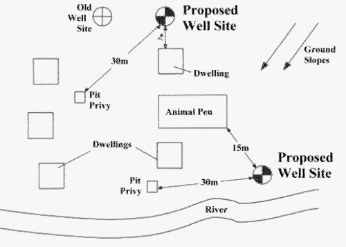
Well water should be tested (Section 16) to ensure that it is free from disease-causing organisms. Also, if it is not clear and good tasting, people may revert to traditional unsafe drinking water supplies. Therefore, avoid drilling in areas where unsuitable quality water is known to occur and keep wells as far away as possible from potential sources of pollution (see Figure 4 and Table 1):
| Distance(m) | Possible Source of Contamination |
| 100 | Garbage dumps/refuse piles, car repair or fuel (petrol) sales outlets, industrial operations/storage facilities etc. |
| 50 | Seepage pit or cesspool |
| 30 | Pit toilets, animal pens, barns, fields fertilized with dung |
| 15 | Septic tank, surface water body |
| 7 | Drain, ditch, house |
Locate wells upgradient (uphill) of nearby potential sources of pollution (i.e., the land should NOT slope from pollution sources towards water wells). If this can not be avoided, try to locate wells as far to the side of the slope as possible (i.e., not directly downslope of possible contaminant sources).
Issues of accessibility to well should be clearly addressed in the Community Water Supply Agreement (see Appendix R). Wells should be as close as possible to houses because people use a lot less water if wells are located far from their home. Usage drops from 40 litres per day (lpd) per person when water is supplied in the yard down to 15 lpd for sources 200 m away; this rate holds fairly constant for distances up to 1,000 meters (Cairncross, 1987). Only when water wells are located more than 1 km from home does the water consumption rate drop again, often declining to less than 7 lpd(2). This means that the most significant benefits (arising from increased water consumption) occur when water wells replace old water sources which were further than one kilometer away (Cairncross, 1987)(3)!
Another factor in preparing Well Development Plans is to determine how many wells are needed to serve the population. When more than 300 people use one handpump, there will be significant waiting lines to get water.
Ensure that the site is accessible year-round and that the access route to the water well is not susceptible to flooding. Finally, ensure that the site has legal access which is acceptable to users from a societal standpoint. Land ownership law is usually different than what we are used to and requires careful consideration. Having a water well on someone's property enhances its value and therefore a formal arrangement for access needs to be clearly made before the well is drilled.
A map of the village and surrounding area should be prepared. Add to the map all relevant features such as houses, animal pens, pit toilets, rivers, swampy areas, garbage disposal areas and indicate the direction in which the land slopes (see Figure 4). Draw all possible well sites on the map and select the best site (try a siting exercise - Appendix D).
There is rarely an ideal location and the relative advantages and disadvantages of each site must be weighed. The people that will be using the well and the drillers must together decide which site is best for the community. Since selecting the best site is a matter of judgement and experience, it always helps to seek assistance from hydrogeologists - while their investigation may be time consuming and add some cost to the drilling project, it will help ensure that a site is selected which will provide a safe, abundant supply of drinking water.
2.9 Sources of Groundwater Information
Information which can help effectively site wells includes aerial photographs, geologic reports, well logs, topographic maps, geophysical maps etc. Sources of this information are listed below. It should again be emphasized, however, that the best sources of well siting information are talking to people who have dug wells nearby and visiting these wells yourself. Keep in mind that:
- Information is often available in-country from government agencies (such as Ministries of Development, Rural Affairs, Geological Survey);
- In-country information is also often available from libraries and international development/aid agencies;
- Often excellent information can be obtained by talking to consultants, hydrogeologists and well drillers who have worked in the area of interest;
- Libraries in most large urban centres in the United States and Canada often contain good information (make use of inter-library loan facilities!). To determine which library is the closest depository for United Nations material, call the UN office at (212) 963-7444;
- Many high quality maps are available from the U.S. Geological Survey (USGS) in Reston Virginia (703) 648-4380 (Mapping Section) or (703) 648-5727 (Geologic Inquiries) or (703) 648-6047 (International Geology Program). They can search for material by key word. Material takes 2-3 weeks to deliver through their Denver office (303-236-7477). For a slightly higher fee, excellent overnight service is available from "Express Maps" (800-627-0039 or 303-989-0003) or "Powers Elevation Co. Inc" (800-824-2550 or 303- 321-2217);
- USGS documents which pre-date 1981 can be obtained from the National Technical Information Service (703-487-4600). They require the NTIS number or the complete document title.
- The United Nations Reference Library (Map Section) in New York is also a good source of information (212-963-0536). Delivery only available through regular mail.
- The Library of Congress (Mapping Section) in Washington DC has many hydrogeological reports and maps for developing countries (202-707-6277). Requests must be made in person or in writing (response time to written search requests is very slow: 2-3 weeks); additional time is required for delivery.
- Hydrogeological reports for many countries of the world are available from the National Groundwater Association (NGWA) Information Centre at 3675 Riverside Dr, Dublin OH, 43107 (800-332-2104). There is an on-line search facility available for a fee; credit card payment and overnight delivery service are available. There is a minimum $12 base fee for retrieving up to 20 pages (extra fee/page for additional pages).
1 Well siting success improved from 50-60 % (based on site reconnaissance and air photo interpretation) to over 90 percent when geophysical technology is used (White, 1987). Geophysical surveys employ instruments that quickly and cheaply measure the physical properties of soil and rock (density, magnetism, electrical conductivity, radioactivity etc.). Geophysical surveys can be very useful in locating water-bearing fault zones, in finding an adequate thickness of overburden or weathered bedrock, and in assessing the depth to the water table (see Hazell et al., 1992 and Reynolds, 1987). Success depends on the application of appropriate techniques, having enough time to do the investigation, and having the equipment operated and the results interpreted by trained geologists (Driscoll, 1986). In some countries, the government provides geophysical surveys as a service.
2 For design purposes, 5 lpd is the minimum consumption level and 25 lpd is an acceptable goal in places where piped connections to individual houses are not feasible (Brush, 197?). It should be noted that the amount of water needed may be much higher if livestock require water and if well water is to be used for irrigate gardens.
3 Education is crucial. Unless people understand the benefits clean water can bring, they will not make effective use of a new well and it may have little benefit (Brush, 197?)! Education is also important for on-going well maintenance; if people see clean water as being vital to them, they will be willing to occasionally spend a little time and money to keep their water supply safe and functioning reliably (Brush, 197?).
Cairncross, S. (1987) "The Benefits of Water Supply", Developing World Water, Hong Kong: Grosvenor Press Int'l, pp. 30-34.
Dijon, R. (1981) "Groundwater Exploration in Crystalline Rocks in Africa", Proceedings of the American Society of Civil Engineers, May 11-15, 1981.
Selby, M.J. (1985). Earth's Changing Surface. Clarendon Press, Oxford, 607pp.
White, C. (1987) "Bore Hole Siting Using Geophysics", Developing World Water, Hong Kong: Grosvenor Press Int'l, pp. 107-113.